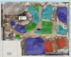
top of page
About

Volumetric Surveys

Cut/Fill Volumes

Stockpiles & Quantities

Change Over Time​​​​​​​​

​​​​​​​

Volumetric survey workflows are commonly undertaken across mining, quarrying, construction, and bulk material handling environments where terrain and stockpile volumes change regularly over time.

​​

+ Using UAV-based aerial capture, datasets can be processed into surface models suitable for stockpile measurement, cut-and-fill analysis, and terrain comparison between survey periods.


+ These processes help create consistent records of material movement and changing site conditions while supporting repeatable monitoring and reporting processes.​​

Operational Value:

+ Improved terrain understanding

+ Improved large-area visibility

+ Accurate volumetric records

+ Consistent stockpile records

+ Repeatable earthworks monitoring

+ Faster access to site data

+ Improved site documentation

+ Planning and reporting support

+ Reduced manual measurement

+ Comparison across survey periods

Screenshot 2026-05-01 155415
Screenshot 2026-05-01 153658
Screenshot 2026-05-01 153152
Screenshot 2026-05-01 155640
Screenshot 2026-05-01 155714
Screenshot 2026-05-01 160749
Screenshot 2026-05-01 160838
Screenshot 2026-05-01 160646
Screenshot 2026-05-01 160622
Screenshot 2026-05-01 155855
Screenshot 2026-05-01 160039
Screenshot 2026-05-01 152919
Screenshot 2026-05-01 152348
Screenshot 2026-05-01 151519
Screenshot 2026-05-01 150828
Screenshot 2026-05-01 150314
Screenshot 2026-05-01 145941
Screenshot 2026-05-01 145754
Screenshot 2026-05-01 144851
Screenshot 2026-05-01 144458
Screenshot 2026-05-01 144333
Screenshot 2026-05-01 144158
Screenshot 2026-05-01 144123
Screenshot 2026-05-01 144106
Screenshot 2026-05-01 105936
Screenshot 2026-05-01 161728
Screenshot 2026-05-01 161712
Screenshot 2026-05-01 161517
Screenshot 2026-05-01 161331
VHL-StockPile-snapshot
VHL-StockPile12-snapshot4
VHL-StockPile12-snapshot
VHL-StockPile_3D_vols_snapshot
VHL-Pile1_large_image1
VHL-Pile2_small_image1
VHL-3dvol_StockPile12-snapshot3
Screenshot 2026-04-28 094808
VHL-3dvol_StockPile12-snapshot2
Screenshot 2026-04-28 095151
VHL-3dvol_StockPile12-snapshot
Screenshot 2026-04-26 165722
Screenshot 2026-04-26 170724
Screenshot 2026-04-26 165822
Screenshot 2026-04-26 165745
Screenshot 2026-04-26 152244
Screenshot 2026-04-26 152348
Screenshot 2026-04-26 152513
Screenshot 2026-04-26 152538
StockPile 12

StockPile 12

ABN 61 181 400 689
CASA ARN 1285035 | ReOC 9511
GeoField is a trading name of Geo Field Enterprises

Aerial distribution contractor licence ADC245097 for aerial distribution of chemicals using an unmanned aerial vehicle (UAV), issued by the Queensland Government Department of Primary Industries.

©2026 GeoField Enterprises

All Rights Reserved​

bottom of page