top of page
About

​Thermal Inspections​​​​​​​​​

Thermal survey workflows provide additional operational visibility by identifying temperature variation and heat anomalies across infrastructure, assets, equipment, and operational environments.​

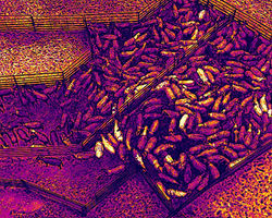
+ Thermal imagery may support inspection and monitoring activities involving roofs, solar installations, industrial equipment, electrical infrastructure, livestock operations, and other environments where temperature variation may indicate developing issues or abnormal conditions.​

Operational Value:

+ ​Improved asset condition awareness

+ ​Faster identification of thermal anomalies

+ ​Thermal and visual inspection records

+ ​Reduced need for elevated access

+ ​Maintenance planning support

+ ​Repeatable monitoring workflows

+ ​Reduced operational disruption

+ ​Improved inspection documentation

+ ​Reporting and operational support

DJI_20260210131023_0018_T
DJI_20260210131012_0017_T
DJI_20260210131009_0016_V
DJI_20260210130647_0013_V
DJI_20260210130958_0015_V
DJI_20260210130958_0015_T
DJI_20260210130647_0013_T
DJI_20260210130639_0012_T
DJI_20260210130607_0011_T
DJI_20260210130520_0009_V
DJI_20260210130526_0010_T
DJI_20260210130017_0003_V
DJI_20260210130006_0001_V
DJI_20260210130230_0005_T
DJI_20260210130230_0005_V
DJI_20260210123538_0015_V
DJI_20260210122913_0012_V
DJI_20260210122814_0011_V
DJI_20260210123538_0015_T
DJI_20260210123047_0014_T
DJI_20260210122814_0011_T
DJI_20260210122753_0010_T
DJI_20260210122733_0009_T
DJI_20260210122725_0008_V
DJI_20260210122725_0008_T
DJI_20260210122321_0005_V
DJI_20260210122545_0007_T
DJI_20260210122310_0004_V
DJI_20260210122321_0005_T
DJI_20260210122310_0004_T
DJI_20260210122222_0001_V
DJI_20260210122252_0003_V
DJI_20260210122252_0003_T
DJI_20260210122222_0001_T
DJI_20260210121408_0018_V
DJI_20260210121204_0017_V
DJI_20260210121133_0012_V
DJI_20260210121433_0019_T
DJI_20260210121433_0019_V
DJI_20260210121514_0020_T
DJI_20260210121408_0018_T
DJI_20260210121204_0017_T
DJI_20260210121151_0015_T
DJI_20260210120901_0009_V
DJI_20260210121148_0014_T
DJI_20260210121133_0012_T
DJI_20260210120803_0008_V
DJI_20260210120437_0003_V

Independent geospatial field specialist supporting surveying, GIS, UAV and spatial projects across Queensland and Australia.

ABN 61 181 400 689
CASA ARN 1285035 | ReOC 9511

Aerial distribution contractor licence ADC245097 issued by the Queensland Government Department of Primary Industries.

2026 Geofield

All rights reserved​.

Toowoomba & Victoria Hill, Queensland, Australia

​Geofield provides specialist drone operations in support of surveying and project teams. Where applicable, survey control, cadastral interpretation and professional survey certification remain the responsibility of the engaging registered surveyor.

bottom of page